METHODS
LUC4FIRE project will first calculate statistical and spatial models to predict historical forest fire occurrence (1970-2015). Then, Land Use Changes (LUC) will be analyzed to estimate afterwards LUC scenarios and future projections (years 2025 and 2050). The obtained historical forest fire models will be applied to the calculated scenarios. Forest fire ocurrence in the future as well as other results will be available through a web tool service.
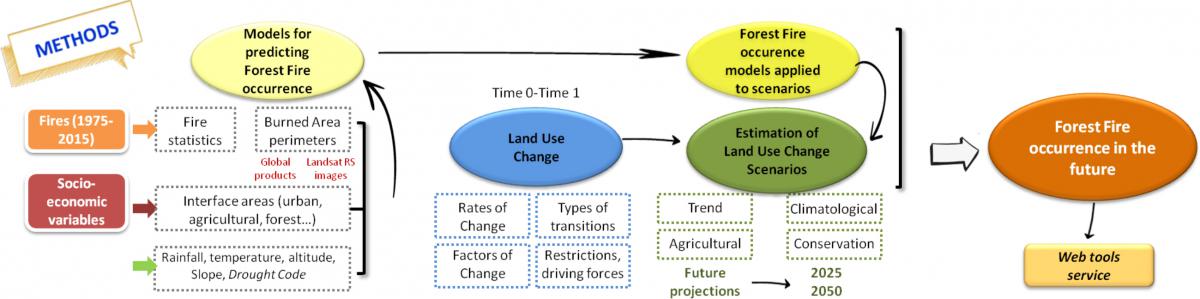
The probability of fire occurrence will be obtained from historic fire occurrence (1970-2015 period) and (1) socio-economic (land use interfaces) (2) biophysical variables and (3) a combination of both socio-economic and biophysical variables.
LUC rates of change will be calculated and the types of transition analyzed. Factors of change, restrictions and driving forces will be defined and taken into account for the analysis of future scenarios.
Then, future land use change scenarios will be produced within the following storylines:
- Business as usual: LUC evolve following the past trends
- Climatic: LUC under A1B emissions scenario
- Agricultural: LUC related to agricultural and farming activities transformation
- Conservation: LUC leaded by bigger protection of the natural areas
Scenarios will be elaborated for 2025 and 2050 in the proposed study sites by using CLUE-S and Dinamica Ego (Environment for Geoprocessing Objects) softwares.
The obtained models to predict historical forest fire occurrence will be applied to the land use maps generated in the future scenarios of the study sites. Also, the analysis will be done regarding what land use type or interface would be positively or negatively related to forest fire occurrence estimated.
The results obtained within LUC4FIRE project as burnt area and LUC maps, future scenarios or produced forest fire occurrence, would be available for the users or stakeholders through a Web tool service.